Tips & Tricks
QC Trails has many special features and functions that can help you find and explore great trails in the Quad Cities region. Once you’ve mastered the basics (see Map Basics and Search Basics), check out some of our favorite Tips & Tricks that might not be as obvious at first glance.
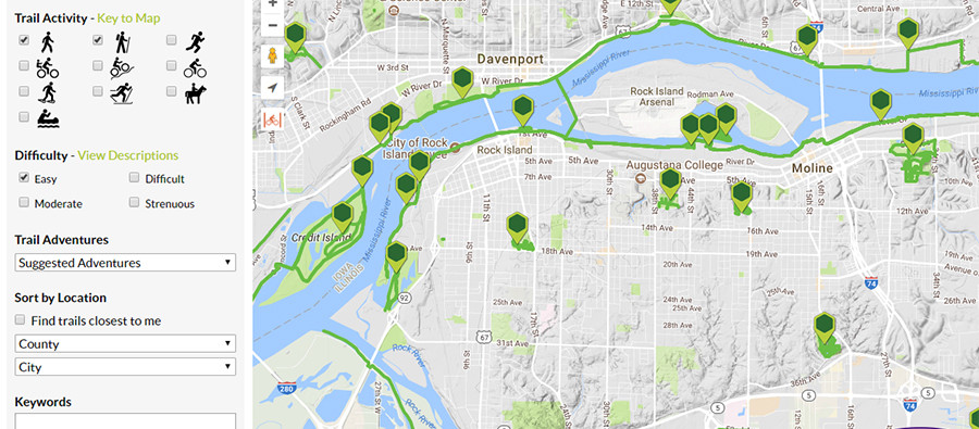
- On the Find Trails page, “zoom in” (+) the map display and the actual trail lines (in green and blue) will appear. You can see how trails connect throughout the region. Since each trail only gets one map pin to represent it, you might be surprised to see how extensive and interconnected trails are!
- Many regional trails are interconnected. On many detailed trail pages you can Show Connector Trails to see how the trail you are looking at fits with others nearby. Click “Show on map” to display the lines for a connector trail on the map. Click “View trail posting” to open the detailed trail page for a connector trail.
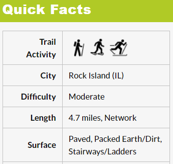 Use the Quick Facts and Photos to quickly assess if the trail is right for you. It can be helpful to note the surface of the trail (is it paved or crushed gravel?) when first considering if you want to visit and what clothing or equipment you might need.
 - Most trails include an elevation profile showing you how much up and down you can expect on the trail. (Some very short, flat trails do not have profiles, so if you don’t see one, it shouldn’t be steep!)
- QC Trails account holders (Create Account) have the ability to post and share comments about individual trails. User comments are displayed at the bottom of the page and may include descriptions of a person’s experience, alternate directions to a trailhead, or advice on when to go. Feel free to share your own comments, too!
 Ready to head out, but you’d like to print out a paper map of a trail page to take with you? Click “Printer Friendly Version” just below the map on the left to open a new page with printer friendly formatting. You can change the base map before printing to something less color-intensive, like “Map” or “Terrain.”
 Show your location. If you are using QC Trails on a mobile phone with Wifi or cellular data service, click the “Go to my location” button on a detailed trail page. Enable location services by saying “Yes” when your browser asks if you will allow QC Trails to determine your location. A blue dot will then appear on the map showing QC Trails’ best guess at where you are! As you move down the trail or road, the blue dot will move with you. This is a convenient way from your browser to track progress or see where you are on the trail.
  Download GPX or KML files to use on your own computer or GPS-enabled devices. KML files can be viewed in Google Earth and GPX files can be uploaded to GPS-enabled devices to take on the trail with you, or just browsed in GPS software on your computer. Learn more about downloading data here.
- The handy Current Weather section in the left column can help you prepare just before you head out. Will you need sunscreen, a raincoat, or warm hat and gloves? Or you can click the link to Weather Underground to see the forecast to plan for a future outing.
 Add a fun challenge to your outing by Geocaching on or near your trail. Geocaching is a real-world, outdoor treasure hunting game using GPS-enabled devices. Participants navigate to a specific set of GPS coordinates and then attempt to find the geocache (container) hidden at that location. QC Trails displays a “Nearby Geocaches” section in the left column of each trail page (under the weather report). This link will take you to geocaching.com. If you’re logged into an account on their site, the link will take you straight to a map of local geocaches found in the vicinity of the trail you were just viewing. Otherwise login or make a new, free account to start exploring (once logged in, you can use the “Nearby Geocaches” link again to take you to the geocaches near your trail).
 - Do you have a specific question about a trail? Try contacting the trail manager using the information provided near the bottom of the page. You can also contact QC Trails directly, who may be able to help or connect you with someone who can (Contact Us).
 Use the sharing widgets shown below and to the right of a trail map to quickly share the link to a particular trail page with your friends using Facebook, Twitter, email, and many other social media platforms.