


Show Connector Trails
This trail is located close to or on open water, wetlands, or floodplain. Please use caution and be alert for water near or on the trail. Be alert for flooding and swiftly moving water. Check with your local trail manager for more information on closures during periods of high water.
Trailhead Information
Individuals seeking access to this portion of the Great River Trail will find it in the heart of Port Byron off of S Main Street and Cherry Street. Many other opportunities to get out of your car and on the trail can be found along High Street which the path follows along into Cordova.
Description
Access the Great River Trail along this link between the Villages of Port Byron and Cordova and you'll be treated to breathtaking views across the "Father of Waters," abundant wildlife, and an easy to moderate trail experience in terms of effort.
The Great River Trail (GRT) runs beside the Mississippi River through the Quad Cities region from Sunset Park in Rock Island to the Rock Island County-Whiteside County line. This section of the GRT is part of the larger 66-mile GRT mile trail system that extends from Rock Island, Illinois at its south end to Savanna, Illinois at its northern terminus. The GRT is widely used as an alternative transportation link and for both active and passive recreational benefits. In addition, the trail provides access and connections to neighborhoods, commercial districts, industrial areas, recreational areas, and historical landmarks. The trail parallels the Great River Road National Scenic Byway (Illinois state highways 92 and 84) throughout the region.
Other Information
The Great River Trail is also part of three other significant trail networks: the Mississippi River Trail (MRT), the American Discovery Trail (ADT), and the Grand Illinois Trail (GIT). The MRT is a 3,000 mile trail system that follows the Mississippi River from the headwaters in Itasca, Minnesota to its delta at the Gulf of Mexico near New Orleans, Louisiana. The ADT traverses the U.S. coast to coast from California to Delaware for more than 6,800 miles across 15 states. As it loops more than 500 miles between Lake Michigan and the Mississippi River, the entire Grand Illinois Trail joins together existing and proposed state and local trails to create the state’s longest continuous trail. It hugs historic canals, crosses unglaciated hills, parallels the Rock and Fox Rivers, and includes one of America’s first rail-trails.
Elevation Profile
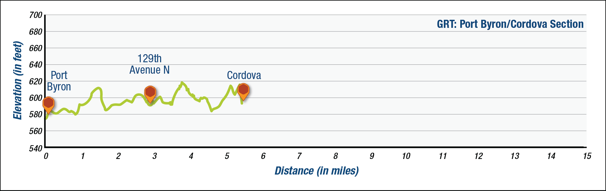
The elevation profile above approximates terrain along the specified section of trail and is provided for general information. Use your best judgment to choose trails with elevation changes to match your comfort level. See QC Trails Terms of Use for more information.
Trail Managers
Visit the Village of Port Byron, the Village or Cordova, or the Rock Island Forest Preserve District online for more information or contact:

Rock Island County Forest Preserve District
19406 Loud Thunder Road
Illinois City, IL 61259
Phone: (309) 795-1040
jcraver@ricfpd.org

Village of Cordova, Illinois
906 Main Avenue
Cordova, IL 61242
Phone: (309) 654-2620
cordovavillage@mchsi.com
Village of Port Byron, Illinois
P.O. Box 438
120 S. Main Street
Port Byron, IL 61275
Phone: (309) 523-3705
portbyronclerk@mediacombb.net
Photos
Comments

BEN DOMINGEZ - June 17, 2016
Use caution in this section between Port Byron and Cordova is rough and mostly one lane due to overgrown vegetation.